Following the pioneers’ footsteps through some of the West’s harshest landscapes

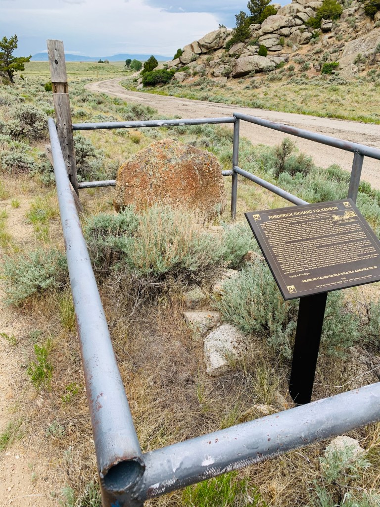
The only sound is the incessant Wyoming wind. Low gray clouds block the warmth of the sun, so I keep my hands in my pockets. I’m standing next to the final resting place of Frederick Fulkerson, who died in 1847 as his family traveled the Oregon Trail. When the 17 year old was buried here, his grave was just a few feet from the route of the greatest land migration in recorded human history. Today, it’s an abandoned highway with cracked pavement slowly eroding to dust, tucked between two hills and out of sight of the current highway. No one passes by, and no one stops in curiosity.
The inscription on the rough granite rock serving as Frederick’s headstone wore away over 150 years ago. The grave was a mystery until a trail historian matched the headstone with a sketch in a pioneer diary. That amazing coincidence saved Frederick from isolated anonymity.
We know a little about the Fulkersons’ story. Frederick, the oldest of James and Mary’s seven children, became ill after he swam the family’s livestock across the North Platte River near present day Casper. The river there is wide, swift, and bone chilling. His conditioned quickly worsened, but he managed to hang on for a week or two, during which time the family continued their journey west to this remote place. It must have been heart wrenching for his parents to lay him at rest here, knowing they would never pass this way again. Two weeks later, Frederick’s mother died near the Green River crossing.
Travelers would have seen many graves like Frederick’s along the way. The Oregon Trail has been called the longest cemetery in the world. Over fifty thousand people met their fate along the way, roughly ten percent of those who made the journey. Did the Fulkersons fully understand the danger and the risks? If they did, what gut wrenching conversations did James and Mary have before they left, knowing at least one member of their family was statistically guaranteed to not make it to Oregon?
I came to Wyoming to better understand the hardships Oregon Trail pioneers faced. Most of them left behind everything they had ever known for nothing more than the promise of an uncertain future. Some of the most unforgiving land they would cross is here in central Wyoming. The landscape is big and it is inspiring. It’s what people imagine when they think of the West: wide open, windswept, desolate. The mountains never seem to budge from the horizon, as if they’re moving with you but keeping their distance. The land feels unchanged since creation. Traveling through it is traveling back in time.
Quietly and to myself, I read a plaque at Frederick’s grave. The Oregon-California Trail Association placed it here when they identified it in 1995. I reflect on the Oregon Trail video game I played as a kid and lament my character’s frequent fate of dying from diphtheria. Now, in this moment, the Oregon Trail was no longer just a video game to me. To Frederick, it was certainly a very real, very dangerous place. I get behind the wheel of my SUV and drive back to the highway. There’s not a car in sight as I turn west onto Wyoming highway 220.
Just down the highway is Martin’s Cove and Devil’s Gate, where the Sweetwater River has carved a 370-foot deep gorge. In 1856, this was the scene of a harrowing fight for survival by a group of Mormon pioneers. They left Independence, Missouri, dangerously late in the traveling season, and were caught in a blizzard here in November. Of the five hundred that started the journey, 145 never made it to Salt Lake City. Many of them are buried at Martin’s Cove.
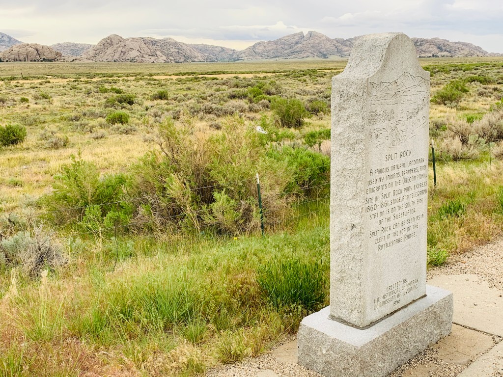
From here I could see the next major landmark on the trail, Split Rock. It takes me about 30 minutes to drive from Devil’s Gate to Split Rock, including the time it took me to get gas (Pro tip: never miss a chance to top off your tank in central Wyoming). The same distance took Oregon Trail pioneers an entire day.
I struggle to grasp that I can travel in 20 minutes what took them a hard day’s journey. They would see the same landmark over the course of several days. The anticipation of seeing each one was met by relief and sometimes celebration when they reached it. In a matter of an hour, those same landmarks are a vague memory to me. And if I’m traveling in an airplane, I never see the landmark at all. Modern transportation has all but removed the journey from travel. Only the destination matters to us now.
Split Rock is a low granite mountain with a pronounced notch in the peak. It’s east of me, across the Sweetwater River. Between Split Rock and the highway pull off where I’m standing, wagon trains would camp in the wide, green valley. The river is a gloried stream–like most in the mountain west near their sources. Still, crossing this river could be treacherous and time consuming. The Oregon Trail is more of a general path in this area; it varied over time as better routes with fewer river crossings became more popular. The trail seemed to have a love-hate relationship with rivers. Travelers dreaded river crossings because of their danger. Yet rivers provided the fresh drinking water that made the trip possible at all. Indeed, the trail followed rivers most of its length and they were a constant travel companion—much like this incessant Wyoming wind.
The wind and I had a particular difficult time getting along the night before. Just after sunset, I found a good camping spot on some BLM land not far from Independence Rock. It was at the crest of a sagebrush ridge overlooking the Sweetwater valley. The wind blew just hard enough to force me to stake down my new backpacking tent. Yet it wasn’t gusting enough to disperse a Mosquito plague of Biblical proportions. They swarmed around me, and each time I drew my hands down the opposing arm, I brushed off at least a dozen of the damn things. And for every one I successfully swatted to oblivion, two more replaced it.
I escaped into my tent after a couple minutes of Mosquito fighting. But the fun had just begun. As I settled in for a restful sleep under a full moon, I peered into the night through my mesh tent wall. I noticed what seemed to be a thin layer of fog moving in from the mountains to the west. I thought it strange that fog would be rolling in, but I didn’t think much of it. Suddenly, that steady Wyoming wind exploded into an inland hurricane. What I thought was fog was actually dust. For over an hour, I held my hands against the tent wall above my head to keep it from collapsing and snapping the poles. Sand blasted against my tent, roaring like pouring rain. Dust fine enough to seep through the tent mesh collected on my sleeping bag and everywhere inside my tent. At about 1 a.m., when I felt a few rain droplets, I had had enough. I jumped from my tent, detached it from the poles, unstaked it, and threw it with everything still inside into my SUV. I rode out the rest of the night in my Nissan. It never rained much, but the wind rocked my truck for hours. I learned later that this was a derecho, a powerful wind storm that is rare in this part of the country (https://www.washingtonpost.com/weather/2020/06/08/denver-derecho/). It was called “historic.” Fitting.
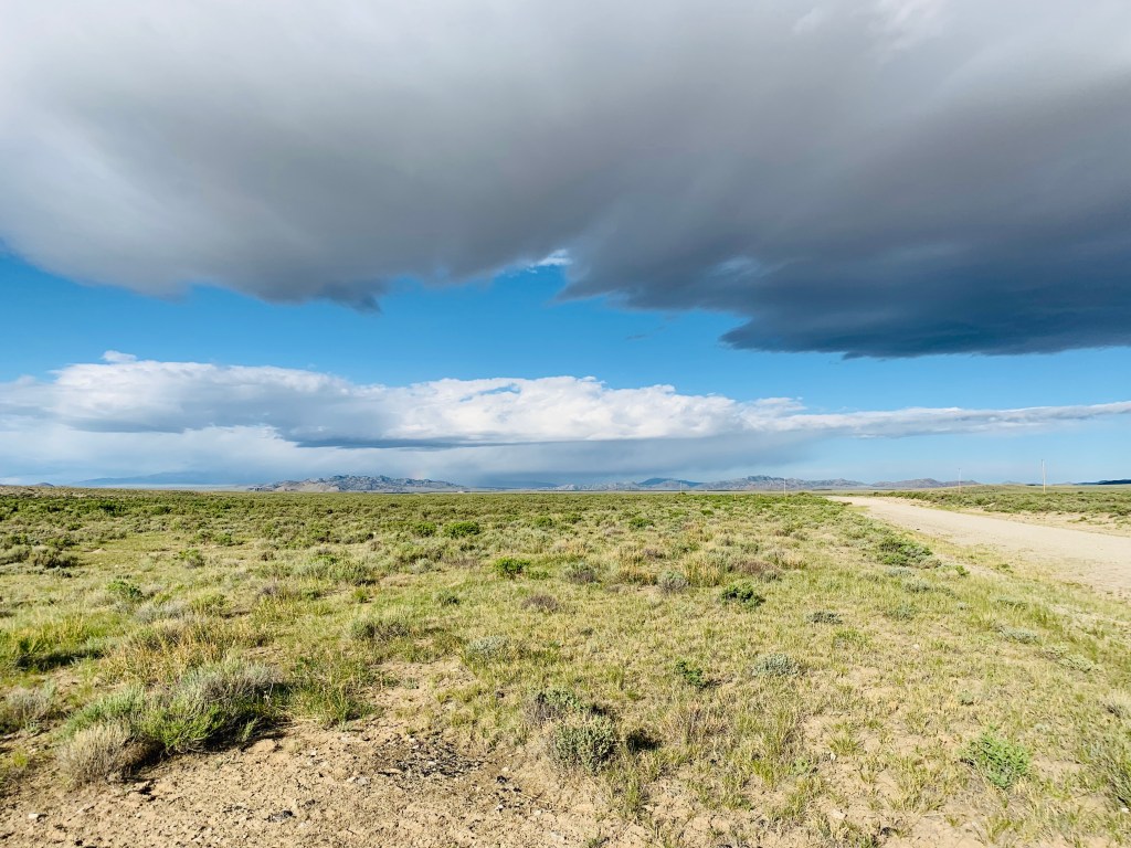
Back to the present at Split Rock. The clouds look like they’re promising to bring the rain that never really came last night. I still have a lot I want to see today, so I jump back into my SUV and drive further west on the highway. I stop at a place called Ice Slough, a marshy area where a thick layer of sod insulated frozen ground water. This was a popular place with travelers, who would dig through the sod and chip away at the ice for their drinks and for chewing. Many pioneers would bring a bottle of whiskey or bourbon to have with the ice here. Today, the underground springs have dried up, a victim of our changing climate.
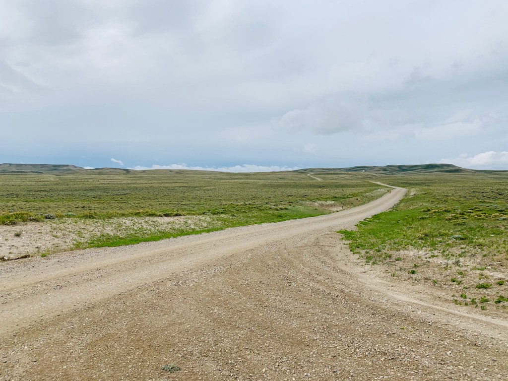
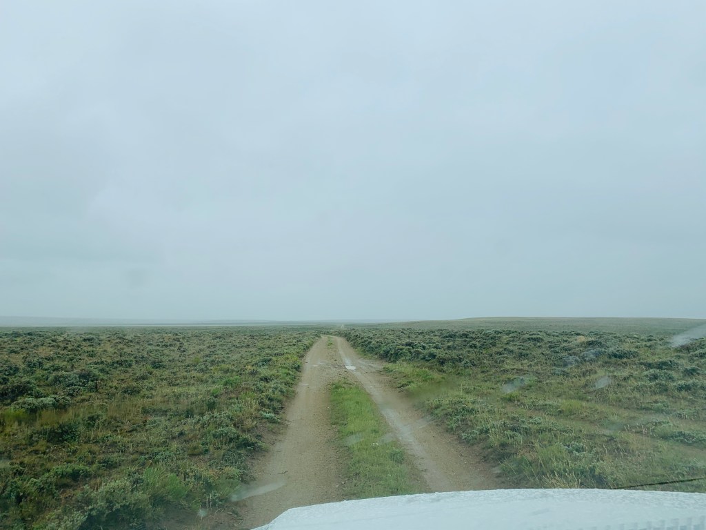
Just a few miles from Ice Slough, I turn off the highway onto a country road in the middle of absolutely nowhere. Called the Atlantic City Road, it runs generally southwest and roughly parallels the trail for the next 30 miles. In my windshield, it twists through low treeless hills. Though it starts as a wide, well maintained gravel thoroughfare, it becomes sketchier the further west I drive. It narrows to one car width and the gravel disappears to rock and dirt.
I approach a side road that would lead me to Rocky Ridge—one of the planned highlights of my trip. Here, the Oregon Trail climbed a steep stony slope, gaining about 700 feet in two miles through rows and rows of rocky riffles like shingles on a roof. It was one of the most rugged and difficult obstacles on the entire trail. But I question whether I’m going to see it. The rain is falling and the road is becoming slippery. When trip planning a few weeks earlier, I read that roads in this area—especially unimproved like this particular side road—become boggy in a rainstorm and nearly impassable for most vehicles. While I would baja without a care down these sagebrush ruts in my Jeep Wrangler, this weekend I am driving the family Nissan SUV. While it is 4×4, its tires are anything but off-road worthy. And in my mind I hear my wife lecturing me about my decision making if I end up stranding the family SUV for a day or more in the Wyoming back country. I turn around after about a hundred yards. Rocky Ridge will have to wait for another trip.
[I am planning a similar trip in 2021 to this area of Wyoming to see some Oregon Trail sites I missed—and to do some fly fishing in the Sweetwater River of course. With some good luck and better weather, I will add to this narrative a section about Rocky Ridge.]
I continue moving west on the Atlantic City Road, heading straight into the heavy rain that the clouds have threatened to bring all morning. The Nissan has trouble gripping onto the slick mud and wants to fish tail down some hills. Pressing on the accelerator straightens the truck but gives me an uncomfortable rate of speed on what essentially feels like ice. I nearly slide into a pond around one curve, but the wheels catch some ruts that track me around the curve like I’m on rails.
The rain subsides and the road improves the closer I get to Atlantic City. Eventually, I end up at a place called Rock Hollow. Remember those Mormons who got a late start on the Trail in 1856 and were stranded at Martin’s Cove? Their misery wasn’t over there. A smaller band of the same group made it as far Rocky Ridge, where they too were caught in the storm. They sheltered a few miles west in a ravine along Rock Creek, where more than a dozen froze to death. They were buried here at what is now called Rock Hollow.
It is difficult to write about the Oregon Trail without sounding like a broken record of tragedy.
In thundering silence, I tour the Mormon markers and monuments around Rock Hollow, including the mass grave for the 1856 travelers. The Mormons recently built spotless public restrooms in addition to a campground with a chipper and inviting sign reading “visitors welcome.” It’s very Mormon-like. They have attempted–admirably–to change the narrative of Rock Hollow and Martin’s Cove to an inspiring and heroic tale of survival. Yet I feel anything but inspired. The rush of Rock Creek sounds not like playfully tumbling water but liquid gloom instead. No matter how many steps away from it I take, its volume doesn’t seem to change. It’s as if it’s trying to drown out the screams of the suffering pioneers. I take a few deep breaths, but the air is heavy. I don’t spend much time at Rock Hollow.
From Rock Hollow, the Oregon Trail climbs South Pass, one of the most benign and unassuming crossings of the Continental Divide. Historians have speculated that without South Pass, the settling of the West might have taken much more time and effort. Lewis and Clark nearly died crossing the Divide in the rugged Bitterroot Mountains to the north, and later trappers and explorers wouldn’t believe Native American legends of South Pass. White man discovered it quite by accident. A group of explorers from the Pacific Fur Company stumbled upon it while trying to avoid a band of unfriendly natives. The wide sagebrush plain crossed by the pass gives no indication to the fact it lies upon the spine of the continent. At just over 7,400 feet, it is the lowest crossing of the Divide between the central and southern Rockies. When western explorer and Army lieutenant John C. Fremont reported that travelers could use South Pass without a “toilsome ascent,” migration to Oregon Territory exploded.
Its setting awes me. To the north is Wyoming’s imposing Wind River Range, containing some of the state’s highest peaks at nearly 14,000 feet. To the south are the Oregon Buttes–twin flat topped mountains. In between, the continent seems to just drop off into a 35 mile wide desert rift. It is as isolated as I imagined it would be.
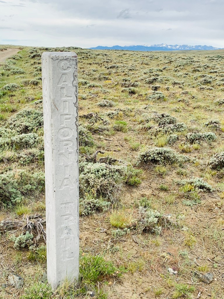
A good gravel road connects me to twin ruts through the sagebrush—the original Oregon Trail. I feel a rush as I guide my wheels onto the trail. I am quite literally driving on history. Through the floorboards, I can feel the sagebrush scrape the truck’s undercarriage. Rain begins to pelt my windshield as I approach the saddle of the pass. There are a few stone markers on the north side of the ruts, so I park the truck off the south side. I get out of the truck and survey the view to the west. The trail noticeably drops in elevation, leaving a view of western Wyoming and Utah that must be grandiose on a clear day. To the east, the landscape appears flat. This view must have been fitting for the travelers—the west inviting them, the east proving few regrets. At this exact spot I’m standing was the border for the Oregon Territory in the 1840s and 1850s. Travelers would have had another thousand miles to the Willamette Valley or to California, but they had reached Oregon. I wonder if this was the first moment they felt a sense of relief or a sense of accomplishment.
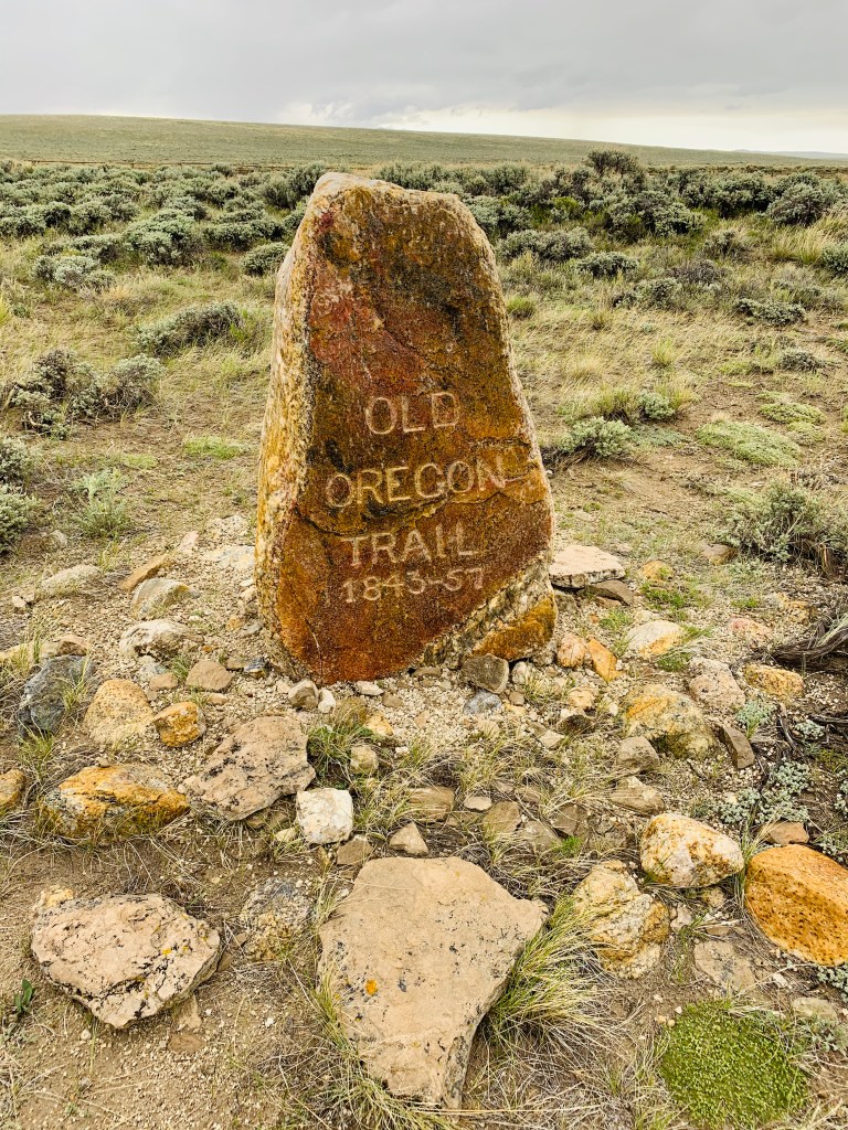
The taps on my raincoat become louder and harder. I’m thankful I haven’t heard any thunder—I don’t see a tree in any direction so I’m the tallest object sticking out of the ground for miles. There’s not much at South Pass to explore. The two stone markers on the north side of the trail are small and simple. One rough granite marker has a short inscription: “Old Oregon Trail 1843-57.” A few feet away another–made of curious and out of place black granite–commemorates the 1836 crossing of Narcissa Whitman and Eliza Spalding, the first American women to travel the Oregon Trail. The Whitmans and Spaldings founded a mission near present day Walla Walla, Washington. For those students of Westward Expansion, the Whitman Mission is an interesting and important story that (you guessed it) ends in tragedy. But it is well worth researching and learning more about.
I spend quite a bit of time at the top of South Pass standing in the rain, soaking in the moment and the place. The number of historically significant sites in the United States untouched by time is staggeringly low. This is a special moment and a special place. Everywhere I look, the landscape is virtually the same as it was when our ancestors stood in this exact spot 170 years ago. What they saw is what I see; the isolation I feel must be something like what they felt. I wonder if I have reached the apex in my weekend quest for understanding.
I soon learn that I have not.
Fifteen miles and an hour later, I’m sitting in my truck in the highway pull out at the “Parting of the Ways” monument. This is just a tourist marker recognizing the point where the Oregon and California Trails split, for which the actual site is almost 10 miles to the west in the desert.
The California gold rush of 1849 turned the Oregon Trail from a moderately used thoroughfare into the super highway of its time. Within just two years, so many Americans had traveled the trail’s California branch that the state met the population requirements to join the Union.
It’s pouring now, and like at Rocky Ridge, I have to abandon my plans to see the actual site of the Parting of the Ways. I watch the storm rage outside, sheets of rain obscuring the nearby hillsides. Dry inside my truck, I reflect on the rain, on the plague of mosquitos the night before, on the “historic” derecho, on the nervous moments driving the slick wet backroads, on the creepy emptiness I felt at Rock Hollow, and on the loneliness I experienced at Frederick Fulkerson’s quiet grave. I had come to the Oregon Trail to understand the hardships the pioneers faced. Perhaps it gave me exactly what I had been looking for. Sitting warm and dry in my fully enclosed, weather proof, climate controlled SUV, I realize I still have a lot to learn.

One thought on “Wyoming’s Oregon Trail”