My alarm starts shouting at me at 5:30 am, and as I shut it off I think I hear snow falling on my tent. I’m not normally up this early on a Saturday, so it takes me a few moments to shake off my grogginess. Considering the weather forecast called for clear skies and highs in the 60s, I’m confused. I unzip the door and peek outside—snow indeed, and it is dumping. The wind roars through the pines above me. I roll my eyes and sigh in aggravation; I didn’t pack for a blizzard.
My wife had graciously agreed to look after the kids for an entire weekend so I could introvert my way to improved mental health. I was going camping and climbing alone for three days in the mighty Sawatch Mountains of central Colorado. One of my major goals in life is to conquer all 54-ish Colorado 14ers (the number depends on what list you use) before my kids reach their own apparent goal of wearing me down to a feeble and haggard middle-aged progenitor. With the kids making more progress on their goal than I’m making on mine, it was imperative I maximized the 14ers I could climb this weekend. I set my sights on three peaks I could climb in two days: Huron Peak, Mt. Harvard, and Mt. Columbia.
The forecast for the weekend was nearly perfect. After some rain showers and a little snow off and on through the week, Friday was expected to be partly cloudy and Saturday was supposed to be clear. Temperatures were forecasted to be mild, with highs in the 50s on Friday and rising to the 60s on Saturday.
The light rain on my way out of town on Thursday didn’t bother me. It made a gentle drumming on my Jeep’s canvas top that served to calm me from my hectic workday. It stopped in the foothills, though, and I made Buena Vista in great time, where I stopped for a burger at K’s (https://www.facebook.com/Ks-Dairy-Delite-264983416594/?rf=147153585315102) to fuel my weekend with greasy deliciousness.
A light rain started again as I drove north out of town. I was making good time until a few miles after I turned west from highway 24 onto county road 390. This bone jarring washboard of a lightly maintained debacle forced me to slow to speeds considered breathtaking by 1880s standards (which was obviously the last time it was graded) just to keep my Jeep from falling apart and/or sliding off the road on sharp turns. When darkness descended, my headlights cast eerie roaming shadows on golden aspens as I crept (and rattled) through the well-preserved ghost towns of Vicksburg and Winfield.
The rain picked up a little as I reached the end of the washboard “road” and the beginning of a 4×4 trail that led to Huron’s trailhead. Finally, I thought, I would be on a smoother road. I put the Wrangler into four wheel, removed the covers from the off-road lights, reattached various pieces and parts of the Jeep’s suspension, applied healing balm to my jarred, jolted, and sore butt, and started up the trail. It seemed like an easy drive, or perhaps ignorance is bliss and I just couldn’t see the obstacles in the road.
After twenty or so minutes, I arrived at what looked like a trailhead. I saw two other cars parked, so I backtracked a few hundred feet down the road and began to set up my tent in the gentle mist. The darkness absorbed my light and I couldn’t see more than 20 feet around me. The rain picked up again later as I lay in my tent—gently lulling me to sleep.
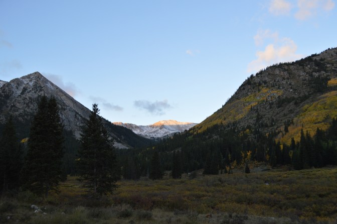
I awoke the next morning to find the rain had turned to snow at some time in the night. Just a dusting covered the ground, but the mountainsides around me had a fresh coat of brilliant white above tree line. I couldn’t see the night before, but I was snuggled into a meadow in a narrow valley that seemed forgotten to the rest of Colorado. It felt isolated and detached—or perhaps that was me, standing alone in the shadows of peaks rising thousands of feet around me, a single rough muddy road winding its way through the meadow and down the valley until it disappeared into the shadowy trees.
The breeze was noticeable but it was the clouds that grabbed my attention—rushing across the sky in a frenzy to be somewhere else. They were puffy and white, so not harbingers of an incoming storm. However, the speed of the upper level winds that were pushing them so quickly must have been staggering. The thought crossed my mind that I might get a taste of that wind at 14,000 feet, but at this moment I chose to ignore it.
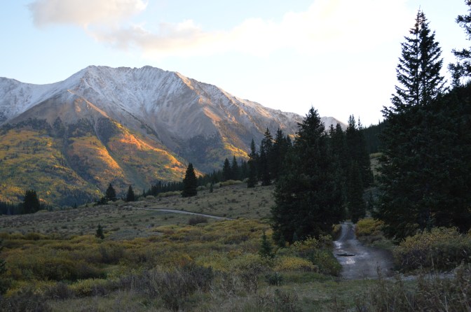
I set out on the trail to Huron Peak shortly after breakfast. Whoever built this trail really enjoyed switchbacks. I counted at least 20. It climbed (quickly) out of the wooded valley and subsequently deposited me in a high alpine basin, with Huron’s pointy peak looming 2,000 feet above me. This is where the ice started. It was freakin’ cold, and suddenly the wind was racing. Whereas in the valley it had to fight through trees, up here—unimpeded—it was vicious. I considered turning back, as I had only packed light gloves, a stocking cap, two layers, and a windbreaker—because, you know, it was still technically summer. Besides, didn’t the weather forecast say clear and sixty degrees? I also knew I’d soon be in the sun, so on I climbed.
The ice turned to snow as I began my assault up the ridge to Huron’s shoulder. Then the snow turned to more snow, which soon turned to foot deep drifts on the trail. I had left my Yaktrax at home, so I knew the descent was going to suck. I gained the ridge of Huron’s shoulder, then pushed up the steep snow clogged talus to Huron’s 14,003 foot summit.
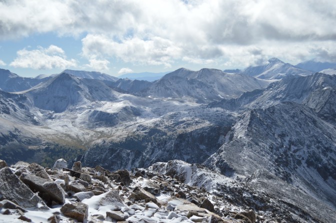
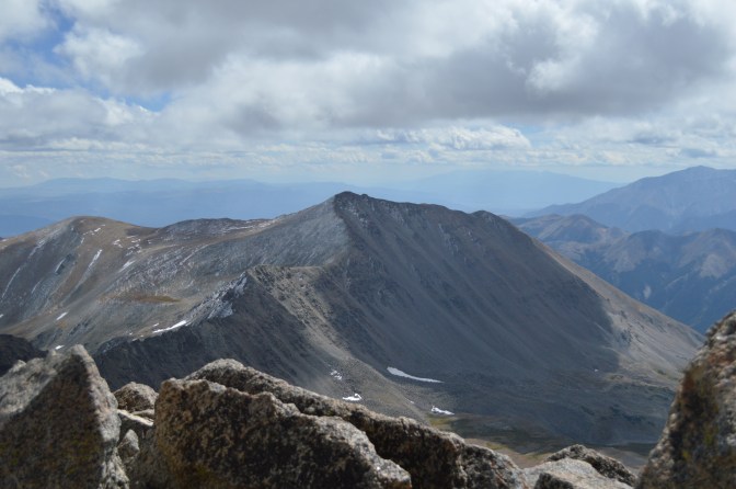
Compared to many other 14ers, Huron has a small summit. There’s room for a few people and a small stone windbreak. Though the platform is small the views are huge. To the west was Taylor Reservoir and my beloved Gunnison Country. In the distance, the rugged San Juans. To the south, fellow 14ers Harvard and Yale ordained control of the horizon. In every direction the Earth is crumpled by violent forces unimaginable; peaks scrape the sky. You are reminded of the insignificance of your own existence.
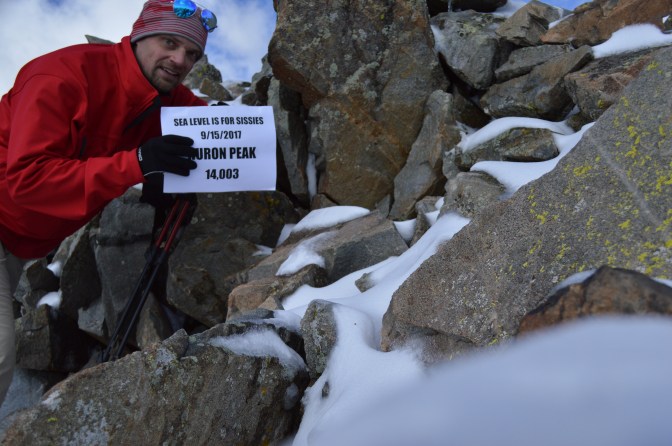
I snapped some pictures and joked with another climber about forgetting to bring skis. Noticing that I had cell service, I messaged my wife to reassure her that I was in fact not yet dead. After another climber joined us it was becoming crowded, so I geared up and wished the other climbers safe hiking—none of us had microspikes—and proceeded down. Besides, I still needed to break camp, drive to Buena Vista for a few supplies, drive to the Harvard trailhead, and backpack 3 miles to that night’s camp. The hike down was not as bad as I had feared, though I had to choose my steps with extra care.
After lunch, I packed up camp and drove down the pleasant 4×4 trail to the hellish county road. Having assumed I made my point earlier regarding how appalling this streak of dirt is, I’ll skip ahead on my adventure. I purchased microspikes and a few supplies in Buena Vista, exchanged messages with my wife, and started for the Harvard trailhead.
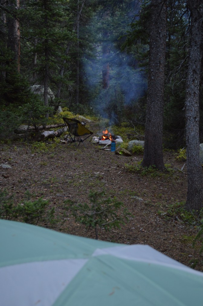
Unlike Huron, you can drive your cah to the Hahvahd (surely you knew that was coming) trailhead. After sorting my gear and packing my backpack for the next two nights, I set off down the trail. The first one and a half miles is easy, wide, and gentle. It follows the idyllic North Cottonwood Creek through a lush canyon. After the second bridge over the creek, the trail narrows, steepens, and becomes much rockier. I had planned to set up base camp after three miles in Horn Fork Basin, but I stopped after two and a half miles at the first decent campsite I could find—my legs were just about to fall off. I had an hour of daylight left, so I set up my tent, filled my water from the excellent stream a short distance away, had dinner, hung my bear bag, started to build a fire, and was chased inside my tent by a sky full of graupel (soft “mountain hail”). Really? This was not in the forecast. But I was tired and I needed to update my trip notes anyway, so I stayed in my tent and called it a night. I dreamed of the adventure awaiting me the next day.
Now it’s Saturday morning and I’m sitting in my tent staring at the dumping snow outside. I decide to wait, but by 7:30 it is still snowing. The sky is heavy overcast, but I begin getting ready. I ready my summit pack, eat breakfast, and carry every layer I have, starting up the trail at 8:45. It is a significantly later start than I planned, and it’s clear this delay may affect my plans to hike the traverse between Harvard and Columbia.
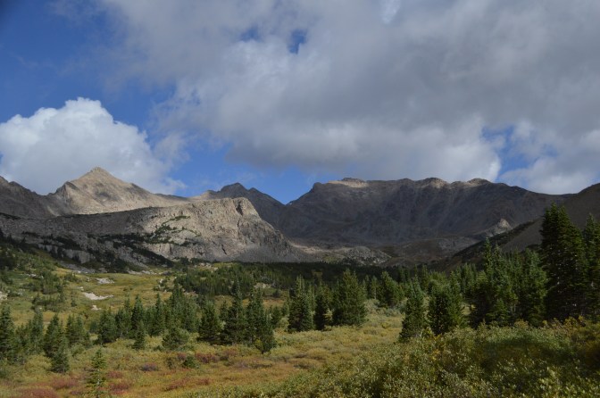
Between Harvard and Columbia is roughly 3 miles of high alpine wilderness. There is no trail, and avoiding a couple of potentially dangerous areas takes focused route finding. A climber descends about 2,000 feet from Harvard to a saddle between the two peaks, then begins to climb up almost 2,000 feet of nothing but talus to reach Columbia. It is not a casual hike.
The snow lets up as I approach timberline, but the westerly wind is still relentless. Halfway up Harvard I meet two climbers on their way down. With full face masks, glacier goggles, puffy pants, arctic jackets, and mountaineering boots with gators, they look like they’re descending from Everest Camp IV.
“Morning,” one greets me. “Careful up there.”
“We had sideways snow up at the top,” the other said. “Had a hard time standing up. Pretty gnarly for September!” he adds with a chuckle.
I must look like a guy from Iowa, with my light gloves, puffy jacket and windbreaker, and stocking cap. I thank them for the info, but with the clouds beginning to break I felt confident I’d be OK.
However, the higher I climb, the more I second-guess the traverse. I remember just yesterday my successful hike up Huron. I trudged through quite a bit of snow up there, and climbing down the steep talus was surprisingly easy, even without microspikes. Today, I have them in my summit pack, so I’m better equipped, right? Yet the clouds were largely broken up yesterday—right now, I can’t see very far west due to a high ridge, but it is still mostly cloudy and windy as hell. On the traverse, I’ll be below the Harvard-Columbia saddle and unable to see west again. This wind can blow in another snowstorm and I may never even see it coming until it’s too late. But I’ve done more than twenty 14ers, some of them multiple times, in literally all conditions. I may not have seen it all, but I know what I’m doing. I’m struggling to make a decision.
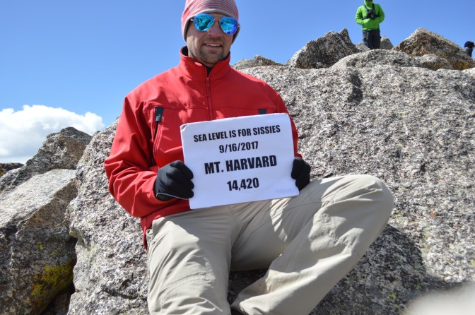
It’s when I reach 12,500 feet that my legs begin feeling noticeably sore. I stop to catch my breath and use it to curse the wind. I have to admit to myself tired climbers with a late start, inadequate clothing, in bad weather climbing alone keep the fine folks at SAR busy. I summit Harvard at 12:30, exhausted from 15 miles of difficult hiking in the last 30 hours. The rule of thumb is you want to expend less than half your energy getting up the mountain so you have plenty in reserve getting down. But I feel like I have less than a full tank and I’m only at the top of the first peak. I decide to not attempt the traverse.
The trail up Harvard, Colorado’s third highest peak, is scenic and remote. Few other 14ers I’ve done leave you above timberline as long, so during summer storm season you want an early start. The trail seems either somewhat level or gruelingly steep; Harvard doesn’t offer much middle ground. The last 30-40 feet at the top requires some route finding and is difficult class 2, perhaps even class 3 depending on how you choose to ascend. There is no standard route on that final pitch.
I’m not saddened by having to forego Columbia. Few 14ers have turned me away (Longs once, Bierstadt at least once), but “summit fever” can be a dangerous condition even for experienced and knowledgeable climbers. Five people died on Capital Peak this year alone. At least two got lost and made a wrong turn down a deceptive couloir that ends at a cliff. They fell 600 feet. Another two were climbing above their ability and met their fate on a feature appropriately called the Knife Edge. The mountains have no sympathy should you make a bad decision.
My fundamental mistake this weekend was giving too much credence to the weather forecast. I’m not normally one to believe much of anything that comes from a meteorologist. This time, inexplicably, I did. It was a good reminder to come prepared for the worst conditions possible, or at least virtually anything.
It was also a good reminder that you don’t successfully climb mountains just because you’re tough, or just because you have special skills. You can check that brand of bulletproof bravado at the trailhead if you ever climb with me. Skills, toughness, determination are all vital, but ultimately you successfully climb mountains because they let you climb them. Each has its own personality, its own tendencies. Each share some characteristics. You have to listen to what the mountain is telling you and look for the message it’s trying to send. Some days all your skills and all your toughness aren’t enough. Some days the avalanche danger is too high, some days lightning is in the area. Every day you need way more brains than you need brawn. Before your trip, you study the map and the route description and know it like it’s your way home—because it is. Humility keeps you alive to climb another day; hubris makes you another tragic statistic.
I arrive back at camp around 4pm and build my first fire of the weekend. The winds have died down and I’m not concerned about burning half of Colorado to the ground. I soak up the fire’s warmth and watch the evening tire until I can barely keep my eyes open. The next day I wake to clear skies and not a breath of wind. I hike the three miles back to the Harvard trailhead in an hour—motivated by a beer at Simple Eatery in Buena Vista (http://www.spoon-it-up.com/). As I sit and sip my beer, I gaze through beautiful weather at the peaks to the west. Over there just out of view is Columbia, patient, waiting for me. And here I am, safe, planning my return.
